



Local Ordinances for Climate Adaptation
Communities are on the forefront of climate change impacts. While federal and state policies can support or hinder local adaptation efforts, often through requirements tied to funding programs, local jurisdictions play a large role in building their own resilience through planning and land use regulations.
READ MOREThis portal provides a repository for examples of local ordinances, model ordinances, and other resources related to local planning and land use that can be used to help local governments adapt to climate change impacts. Beginning with flooding and floodplain management, this portal will be expanded in the future to encompass resources that address other climate-driven hazards.
SHOW LESSGeorgetown Climate Center studied local ordinance-centered approaches to reducing greenhouse gas emissions and identifying and reducing climate-driven flood risk in an October 2025 report, “Local Ordinances for Climate Adaptation & Mitigation.” As part of that project, GCC’s research identified 11 ordinances from Connecticut, Florida, Maryland, New Hampshire, and New Jersey that represent some of the best uses of local ordinances to advance climate adaptation and protect people and property.
Over the past 50 years, scientists have observed a significant surge in weather-related disasters and other trends attributable to climate change, including rising coastal sea levels, increased intensity of storm surges, and more variable and intense precipitation events.
Each year, flooding from storms becomes more frequent and severe. As the climate continues to change, so will the intensity of storms and their impacts to riverine and coastal communities. With each new catastrophic flooding event, people are displaced, insurance prices rise, municipal bond ratings fall, and infrastructure is less able to withstand the damage. Preventing more development in areas at risk of consistent flooding, and building with more resilient standards, will help coastal and riverine communities save money and lives. States and localities can steer construction away from flood-prone areas with forward-thinking floodplain management.
The Federal Emergency Management Agency (FEMA), requires National Flood Insurance Program (NFIP) participating communities to adopt floodplain management practices that meet federal standards. States can choose to adopt standards that exceed federal requirements and provide a heightened baseline for local governments within their jurisdiction.
Local floodplain ordinances provide the legal mechanism for formalizing requirements to identify and address risk.
Use the left-hand navigation to explore ordinances that:
- Expand the mapped floodplain;
- Expand the regulatory floodplain;
- Require new construction, and retrofits, within that floodplain to meet freeboard, or elevation, standards;
- Require new construction to meet minimum setback standards to keep property away from floodwaters; and
- Incorporate community engagement for floodplain management.
Figure: Example climate-adjusted freeboard elevation for New Jersey
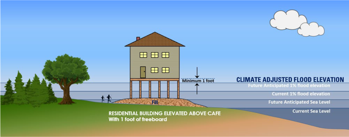
Graphics from the New Jersey Department of Environmental Protection Resilient Environment and Landscapes (NJDEP REAL) Webinar 1: Sea Level Rise & Inundation Risk Zone, May 20, 2024.
