


TerrAdapt: Cascadia Tool
The TerrAdapt:Cascadia tool, founded by a team of practitioners and scientists, is a visualization tool for monitoring habitats and habitat connectivity across the Cascadia region, which covers Washington and portions of Idaho, Montana, Oregon, and British Columbia. The tool projects habitat and ecosystem scenarios utilizing climate and land-use data, and can help users prioritize conservation practices in at-risk areas. In partnership with Cascadia Partners Forum and other regional users, the non-profit TerrAdapt.org developed TerrAdapt:Cascadia to address local and regional decision-making concerning land use and adaptive management processes.
|
Monitor and project regional patterns or changes in patterns to inform land-use policies and conservation efforts in the Pacific Northwest. |

TerrAdapt utilizes a cloud-based system that coordinates with Google Earth Artificial Intelligence technologies and satellite monitoring to locate ecosystem disturbances and regional risks for specific species. Centered on data spanning from 1990 to the present, the mapping and recording tools trace changes in ecosystem patterns and species ranges. This information can then be used to inform land-use practices and assess their impacts upon regional habitats.
Users can access TerrAdapt:Cascadia through the organization’s primary platform: TerrAdapt.org. TerrAdapt:Cascadia provides two key features for its users: the dynamic dashboard and its mapping tool.
Dynamic Dashboard: This feature allows users to view environmental trends in the region by analyzing various layers of data. The dashboard prompts users to filter data across several categories: Theme (biodiversity, climate, disturbance, landscape); Scope (monitoring historic change or projecting future change); Layer (ecosystem type or species type); and Region (Summary area of interest. The default is the entire Cascadia region). The user can adjust the start and end years to their preference and toggle between different regions of the map for greater visibility of impacted regions. The graph results will display trends based on the interactive choices and may provide projections up to the year 2100.
Map Feature: The map feature depicts changes in landscape and how that may impact species and ecosystems. The map allows individuals to monitor (viewing information from 1990-present) and project (present-2100). The information produced by the map allows individuals to identify regions and species that decisionmakers may need to prioritize in future plans. Data ranges from information surrounding the ecosystem domain to that of the species domain. This will allow decisionmakers to plan according to possible trends or changes in trends in this region.
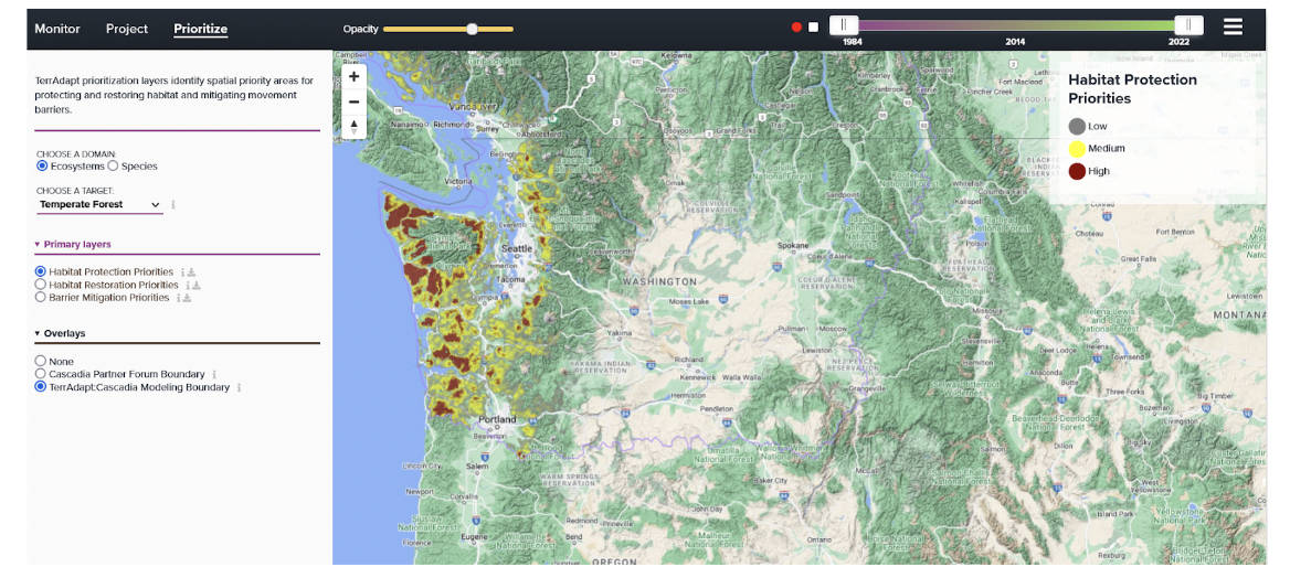
The founders of TerrAdapt:Cascadia developed the tool with the goal of combining local information from conservation and land managers into a regional-scale dataset in order to fill information gaps that may exist across jurisdictions. This will allow for better monitoring and protection of species and ecosystems across borders. By bringing all this information under one tool, TerrAdapt:Cascadia allows land managers to identify key risk zones and priorities. TerrAdapt:Cascadia is mainly targeted toward land managers, regional policymakers, and decisionmakers. These actors may use the mapping and reporting tools to develop adaptive management strategies on both regional and local scales. Primarily, this tool may inform conservation strategies in terms of species and ecosystem ranges. TerrAdapt partners with various foundations and organizations that help advance and fund their services. Some of these partners include Washington Department of Natural Resources, Google, U.S. Fish and Wildlife Service, One Earth, Leonardo DiCaprio Foundation, Wilburforce Foundation, among others. The tool was initially available in 2017, but was updated in December 2022 to make the Dynamic Dashboard available.
Publication Date: 2017
Related Organizations:
- TerrAdapt
- Cascadia Partners Forum
Sectors:
- Biodiversity and ecosystems
- Land management and conservation
- Wildlife
Resource Category:
Resource Types:
- Mapping tool
- Tool (general)
States Affected:
