


Hampton, New Hampshire: 2025 Zoning Ordinance, Building Codes, and Impact Fee Ordinance
This resource is part of a collection of research on Local Ordinances for Climate Adaptation & Mitigation developed by Georgetown Climate Center. See more related resources.
In May 2025, the Hampton, New Hampshire Planning Board adopted the annual update of the Zoning Ordinance and Building Codes to restrict development of critical facilities in flood-prone areas, incorporate sea-level rise, and update freeboard values.
Several neighborhoods in Hampton are prone to frequent flooding – for example, Meadow Pond and Hampton Harbor. In 2021, flood studies were completed for these areas to assess sea-level rise and subsequent flooding, and provided recommendations for flood mitigation. Prior to these studies, the New Hampshire’s Coastal Adaptation Working Group published Coastal Flood Risk Guidance in partnership with the New Hampshire Department of Environmental Services (NHDES), UNH Extension, Piscataqua Region Estuaries Partnership, and NH Sea Grant.
This report was mandated as part of the New Hampshire Revised Statutes Annotated (RSA) 483-B:22, which required that NHDES “supervise an updating of storm surge, sea-level rise, precipitation, and other relevant projections recommended in the coastal risks and hazards commission 2014 report ‘Sea-Level Rise, Storm Surges, and Extreme Precipitation in Coastal New Hampshire: Analysis of Past and Projected Trends’” at least every 5 years. Risk assessments, guidance, and recommendations for Hampton are referenced throughout the Coastal Flood Risk Guidance report, including a suggestion for studying sea-level rise and flooding in the town.
Following the report and studies, the town has updated their Floodplain Ordinance and Building Code several times (as they are updated annually). In 2023, grant funding from NHDES supported work to update the code such that higher standards that account for sea-level rise and flood elevation would be included. The 2025 update builds upon this work to include higher development standards.
Expanded Regulatory Boundaries
Section 4.2.6.7 (Overlay Districts - Groundwater Protection District Ordinance) of the town code prohibits the storage of regulated or hazardous substances in the special flood hazard area, and areas expected to experience sea-level rise per the Hampton Master Plan and the NH Coastal Flood Risk report. Section 4.3.7.3 - Critical Facilities - prohibits construction of future critical facilities within the Special Flood Hazard Area (unless reviewed and approved using guidance from the NH Coastal Flood Risk Guidance, using the “very low tolerance for flood risk” standard). Existing critical facilities due to be replaced or improved must be floodproofed or elevated so that the lowest floor is one foot above the 500-year floodplain, or three feet above the base flood elevation (whichever is higher). These boundaries on development and storage go beyond the standard 100-year floodplain, and incorporate future floodplain geometry by accounting for future sea-level rise.
Enhanced Setback Standards
The Hampton Zoning Code (Article 4) includes references to overlay districts - these are zones with specific (often geographical) qualities and regulations that can be layered atop one another. The Wetland Conservation District, which includes tidal and freshwater wetlands, poorly drained soils, vernal pools, streams, and stream buffers, has particular rules for development per the Code. Section 2.2.5 (Dimensional Requirements) of the code prohibits construction within 12 feet of the town’s Wetland Conservation District. Article 4 (Overlay Districts) Section 4.1.4.3 (Wetland Conservation District) requires that buildings be set back 50 feet from tidal and inland wetlands, poorly drained soils, and vernal pools, and 100 feet from certain types of streams.
Freeboard Standards
The updated code adopts the “Sea Level Rise Design Flood Elevation (SLR DFE)”, which is the “elevation to which buildings in Special Flood Hazard Areas must be built to account for sea level rise. SLR DFE equals the Base Flood Elevation plus freeboard plus anticipated sea level rise,” (Section 4.3.2 - Floodplain Ordinance, Definitions) which is determined by the Hampton Master Plan and the Floodplain Administrator. Section 4.3.7, the Floodplain Development Requirements, mandates that development within the Special Flood Hazard Area is constructed such that electrical, heating, ventilation, plumbing, air conditioning equipment, and other service facilities are elevated to the SLR DFE. The Structure Requirements section (4.3.9.1.1) requires that the lowest floor of new or substantially-improved construction must be elevated to the SLR DFE. As mentioned above, critical facilities have particular freeboard standards in Hampton as well.
Figure 2 from "A Summary of High Tide Flooding Recorded by the Hampton, New Hampshire Tide Gauge: 2013-2020"
Pg. 7 (Dec. 2021)
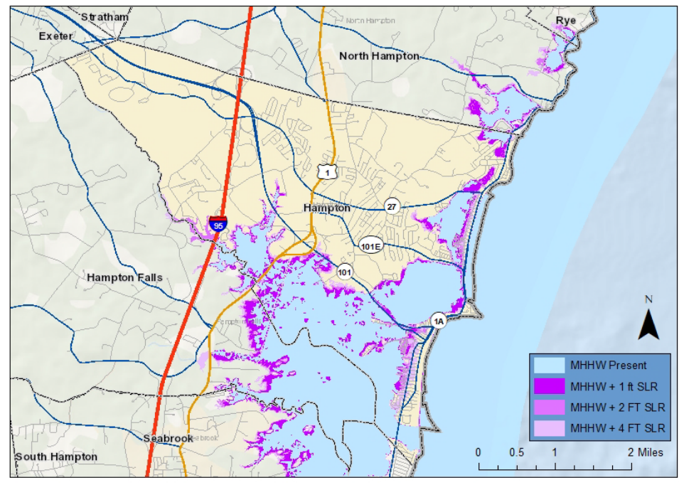
Image Caption: "Map of the Town of Hampton (in yellow), and surrounding areas, depicting the current extent of inundation at Mean Higher High Water (MHHW) and the increase in flood extent under different sea level rise (SLR) scenarios."
Publication Date: May 16, 2025
Related Organizations:
- Hampton Planning Board
Related Resources:
Sectors:
Resource Category:
Resource Types:
- Laws
States Affected:
Impacts:
- Flooding
- Coastal Flooding
