


Havre de Grace, Maryland: Requirements in All Flood Hazard Areas
This resource is part of a collection of research on Local Ordinances for Climate Adaptation & Mitigation developed by Georgetown Climate Center. See more related resources.
On February 1, 2016, the city of Havre de Grace, Maryland, adopted additional provisions to mitigate flood risk, including elevating the city’s freeboard requirements, particularly for critical facilities. Havre de Grace faces flood risk from several waterways, including the Susquehanna River, Lilly Run, Fountain Run, and Gashey’s Creek, and is uniquely vulnerable due to its positioning at the nexus of the Susquehanna River and the Chesapeake Bay.
Article IV of the city’s code, “Requirements in All Flood Hazard Areas,” updates the city’s ordinances regarding construction and zoning requirements of residential buildings, critical facilities, and historical structures, among others. The ordinance is notable for its elevation of freeboard standards for critical facilities (e.g., hospitals, fire stations, etc.) beyond the standard one-hundred-year floodplain.
FEMA Floodplain Map for Havre de Grace, 2016
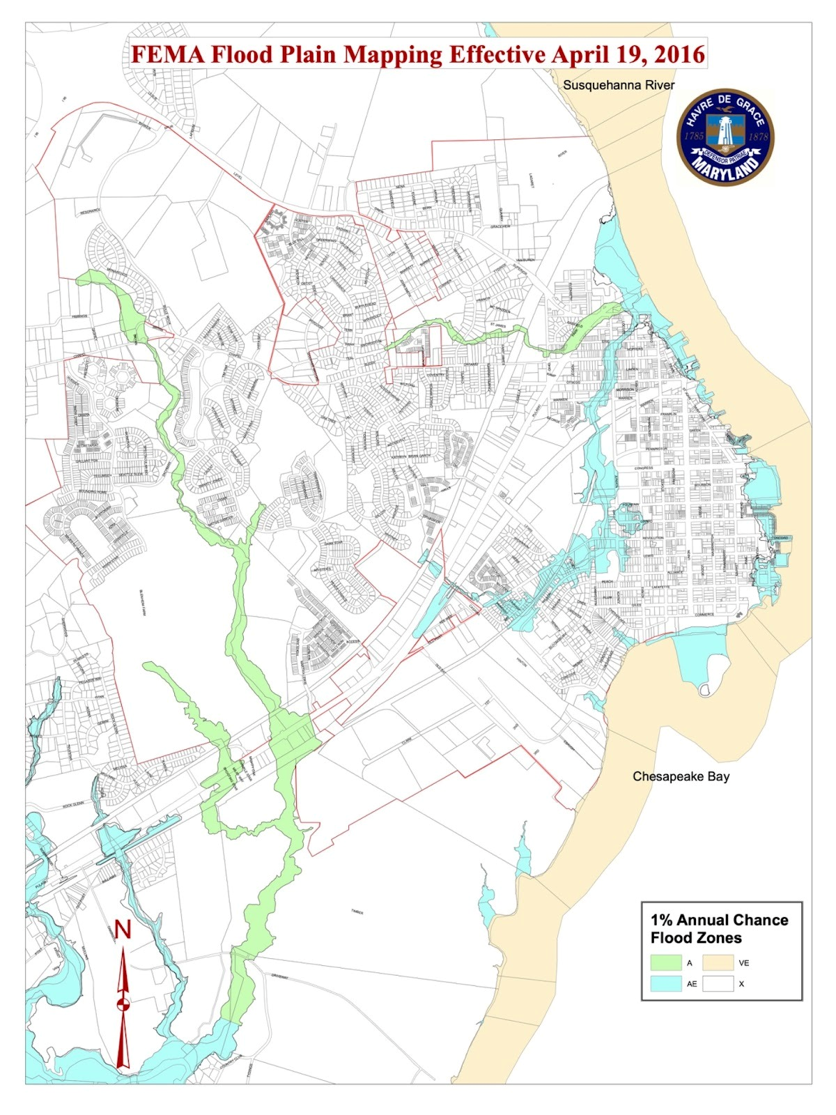
Map showing different flood-risk zones for the 100-year floodplain in Havre de Grace.
Freeboard Standards
The updated code stipulates that in areas of shallow flooding, the lowest floor of residential structures should be elevated at least two to four feet above the 1% annual chance flood level. In areas with a one-percent annual chance of flood, as well as for coastal high-hazard zones, structures should be elevated at or above the flood protection elevation, which is defined as the “base flood elevation plus two feet of freeboard.”
78-27 of the code specifies that critical facilities may not be located in coastal areas with high risk or floodways. If such facilities are located in flood hazard areas other than coastal high hazard areas or floodways, they must be elevated to the “higher of elevation required by this chapter plus one foot, the elevation required by the Building Code, or the elevation of the two-tenths-percent chance (five-hundred-year) flood.”
Additionally, §78-25 of the code states that manufactured homes may not be located in floodways or coastal high-hazard areas. New manufactured homes located outside of such areas should be elevated on a permanent, reinforced foundation and should have demonstrated low flood risk.
Article VI of the code designates that while many of the regulations for other coastal zones apply, in coastal high-hazard areas, there are additional limitations, such as the prohibition of all basement floors and the prohibition of the placement of structural fill for the purpose of elevating buildings.
Enhanced Setback Standards
Article V of the code also specifies that in "A Zones" (special flood hazard areas along nontidal waters of the state, landward of coastal high hazard areas, and landward of Coastal A Zones), no new buildings or structures can be constructed without prior demonstration that the structure will not encroach into the flood protection setback, which is the minimum distance from the top bank of a watercourse to be left undisturbed to minimize flood damage and protect against bank erosion. The flood protection setback is 100 feet if the watercourse has special flood hazard areas (excepting where the setback extends beyond the boundary of the flood hazard area) or 50 feet if the watercourse does not have special flood hazard areas. Residential structures in A zones also must be elevated to or above the flood protection elevation.
Publication Date: February 1, 2016
Related Resources:
Sectors:
Resource Category:
Resource Types:
- Laws
States Affected:
Impacts:
- Flooding
- Coastal Flooding
- Riverine Flooding
