


Satellite Beach, Florida: Floodplain Management Ordinance
This resource is part of a collection of research on Local Ordinances for Climate Adaptation & Mitigation developed by Georgetown Climate Center. See more related resources.
The city of Satellite Beach, FL, published updates to its floodplain management ordinance on March 5, 2014. The town amended existing regulations to increase the flood resilience of critical facilities. Section 3.1 of the city’s code increases Satellite Beach’s freeboard standards beyond standard federal and state requirements to mitigate the city’s risk to coastal flooding and sea-level rise. Satellite Beach faces heightened flood risk due to its location on a long, narrow barrier island; it is situated between the Atlantic Ocean to the east and the Banana River (a sub-estuary within the Indian River Lagoon complex) to the west.
In 2019, in collaboration with Florida Sea Grant, Stetson University, the University of Florida, and the East Central Florida Regional Planning Council, the city of Satellite Beach conducted a sea-level rise vulnerability assessment, which prompted the city to consider flood risk to its critical and public facilities. As a result of the assessment, the city has moved a critical facility, pursued beach restoration, and re-assessed its building codes.
Figure: Satellite Beach 100-Year Floodplain
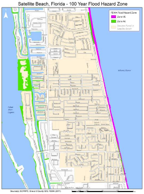
Image caption: Different zones of the 100-year flood hazard zone for Satellite Beach from FEMA data in 2011.
Expanded Regulatory Boundaries
In this update to its floodplain management, Satellite Beach extended the regulatory boundaries of the considered floodplain from the 100-year floodplain to the 500-year floodplain for certain types of structures. Unless a variance is granted, construction of such structures within the 500-year floodplain is prohibited. Section 107.6 outlines the factors taken into consideration when determining whether to issue a variance. Such factors include the danger that materials and debris may be swept onto other lands, resulting in further injury or damage; the danger to life and property due to flooding or erosion damage; the susceptibility of the proposed development, including contents, to flood damage, and the effect of such damage on current and future owners; and more.
Freeboard Standards
If a variance is granted, Section 308.1 outlines that critical facilities should, to the extent feasible, be located outside of the special flood hazard area (100-year floodplain) and outside of the two-percent annual chance flood hazard area (500-year floodplain). If this is not feasible, the facility should have its lowest floors elevated to or above the 0.2-percent annual chance flood hazard area (500-year floodplain) elevation plus 1 foot or to the community’s design flood elevation standard, whichever is higher. Where existing regulations specify elevation requirements, the minimum elevation should be the 0.2-percent annual chance flood hazard area (500-year floodplain) elevation plus 1 foot, or to the community’s design flood elevation standard, whichever is higher. Critical facilities’ access routes should also be above the 0.2-percent annual chance flood hazard area elevation.
Publication Date: Updated Oct 2, 2025
Related Organizations:
- City of Satellite Beach, Florida
Related Resources:
Sectors:
Resource Category:
Resource Types:
- Laws
States Affected:
Impacts:
- Flooding
- Coastal Flooding
