


West Hartford, Connecticut: Special Flood Hazard Area Regulations
This resource is part of a collection of research on Local Ordinances for Climate Adaptation & Mitigation developed by Georgetown Climate Center. See more related resources.
Since 2008, the Town of West Hartford, CT has passed updates to its development regulations for the Special Flood Hazard Area (SFHA; §177-8 of the municipal zoning code) that aim to protect people and the built environment from the impacts of flooding, notably expanding freeboard requirements in 2023. The initial 2008 update followed a FEMA flood study that updated the town’s map of the flood hazard area map.
The Special Flood Hazard Area (SFHA) encompasses the land that would be flooded during a 100-year storm, or a storm that has a 1% chance of happening in a given year, based on the town’s resulting FEMA Flood Insurance Rate Map (FIRM) from 2008. All structures within the floodplain, whether new or up for repair, must meet certain floodproofing standards or may not be permitted. The updated ordinance includes regulations for development in and around the SFHA, elevation requirements for buildings within the SFHA, and additional floodproofing regulations for areas the town has mapped for water quality concerns.
Expanded Regulatory Boundaries
In addition to the standard Special Flood Hazard Area, West Hartford also regulates floodplain development within stream channel encroachment lines (SCEL) established by the Connecticut Department of Environmental Protection in 1964 - 1968. Several reservoirs and additional lands used for floodwater conveyance or storage are also regulated by this ordinance. Section 177-8, D.2 further states that the SFHA includes areas contiguous with the 100-year floodplain that have historically flooded or the potential to flood, and areas below the base flood elevation that are not protected from flooding by natural or manmade structures. These additions to the town code go beyond the federally-defined SFHA, which only covers the 100-year floodplain. West Hartford’s SFHA including areas of potential or historical flooding, in particular, provides additional protection against climate impacts by regulating and floodproofing development in impacted areas.
Figure: Stream Channel Encroachment Lines and Floodzones, Park River North Branch
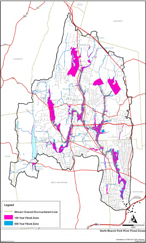
Image caption: Figure 4-3 of Baseline Watershed Assessment, North Branch Park River Watershed, Connecticut Department of Environmental Protection, July 2010.
Freeboard Standards
Sections 177-8.E.2(a) and (b) were amended in April 2023 to require a certain freeboard elevation for structures within the Special Flood Hazard Area. Any new construction or substantial improvement built within the SFHA must elevate the lowest floor of the lowest enclosed, habitable area (including basement) at least 2 feet above the base flood elevation. This also includes utility structures, such as HVAC systems and plumbing features.
Mapping
States and localities often use FEMA’s FIRMs to regulate the floodplain. Localized mapping efforts can provide a basis for further, more specific regulations. West Hartford’s Town Code §177-8, Section C.5 stipulates that “undefined lands near to a watercourse which is susceptible to flooding, whether a floodplain study has been performed or not” are also areas that the floodplain regulation ordinance applies to. One specific area that the regulations apply to is the Park River North Branch on the eastern side of town. In 2010, the Connecticut Department of Energy & Environmental Protection (CTDEEP) developed a North Branch Park River Watershed Management Plan to address water quality concerns. The plan included additional mapping of the watershed, which §177-8.1 (Park River Project water storage area) of the town code relied on to establish special development regulations. Within the water storage area, approval is required to build new structures or develop the land in any way. One stipulation for building approval is that the structure be floodproofed to the standards outlined in §177-8 of the code, in addition to preserving the water storage capacity of the area.
Publication Date: Updated April 11, 2023
Related Organizations:
- Town of West Hartford, Connecticut
Related Resources:
Sectors:
Resource Category:
Resource Types:
- Laws
States Affected:
Impacts:
- Flooding
- Riverine Flooding
