


Ocean City, Maryland: Flood Damage Prevention Ordinance
This resource is part of a collection of research on Local Ordinances for Climate Adaptation & Mitigation developed by Georgetown Climate Center. See more related resources.
The Ocean City, Maryland Code of Ordinances includes a comprehensive flood damage prevention policy (Chapter 38, Article II). The policy, which includes both building hardening standards and floodplain management rules, is meant to protect people, property, and the environment from the impacts of coastal flooding in the city by restricting construction and development in high-risk areas.
The ordinance goes beyond both federal and state minimum recommendations for flood protection. The town implements additional elevation and floodproofing requirements for development in high-exposure areas and near dunes. The elevation requirements explicitly incorporate future sea-level rise for the area to ensure buildings are properly protected from current and future flooding.
Expanded Regulatory Boundaries
The Maryland Department of the Environment sets minimum statewide floodplain regulations, though localities may adopt more restrictive regulations. The state code defines the floodplain as the area that would be covered by water during a flood that has a 1% chance of happening in a given year. This is also called the 100-year floodplain. The Ocean City Code of Ordinances, Chapter 10 (Buildings and Building Regulations) defines a “critical foundation area” that is the most at risk for flooding. The critical foundation area has additional freeboard requirements (described below). Ocean City’s regulatory boundary also encompasses areas near the city’s beach dunes, where permitted development has additional floodproofing requirements as well.
Enhanced Setback Standards
In January 1976, Ocean City surveyed and established an oceanfront building limit, which has since undergone several revisions. Any construction activity is prohibited east of the building line limit, with few exceptions. The details of the line are kept with the Office of the Engineer at City Hall. The city has also established a dune setback line, which is 75 feet west of the beach replenishment project line. The beach replenishment project line cordons off the city’s Beach Replenishment and Hurricane Protection Project. Structures are only able to be built beyond the dune setback line if they are landward of the mean high tide, and are properly elevated with additional floodproofing measures.
Freeboard Standards
If a variance is granted for structures to be built or repaired within high-risk flood zones, they must have additional floodproofing measures. East of the dune setback line, structures must be elevated 15.7 feet above mean sea level. Within the critical foundation area, and west of the dune setback line, the minimum freeboard value is three feet above the base flood elevation. There are several other areas outside of the critical foundation area and FEMA flood zones that require particular freeboard elevations, outlined in Section 38-71 subsections a.4 - a.7. Those freeboard requirements range from the height of nearby boardwalks to an additional two feet above the base flood elevation. When conflicting regulations exist, the more restrictive standard (e.g., the higher freeboard value) prevails. The 2023 Ocean City Hazard Mitigation Plan recognizes that these freeboard values were determined in part by considering the future impacts of sea-level rise on the city.
Figure: Ocean City Freeboard Zones
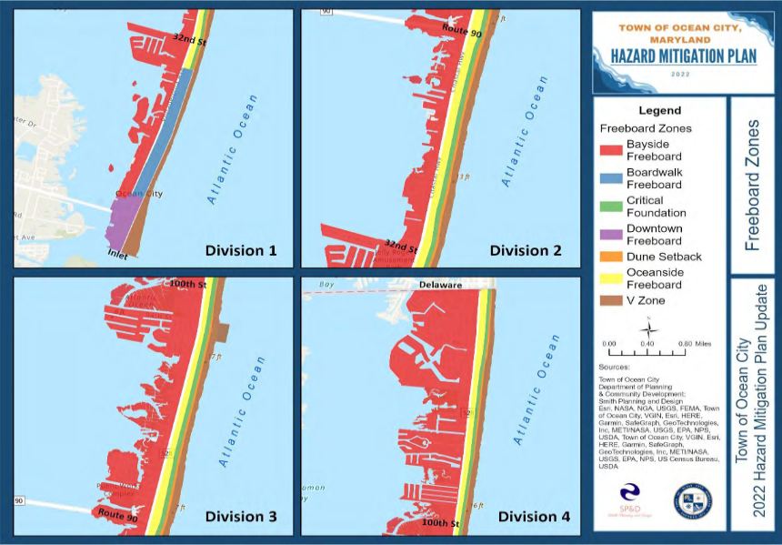
Image caption: Map of different zones with their freeboard requirements from the Ocean City 2023 Hazard Mitigation Plan Update.
Publication Date: July 9, 2025
Related Organizations:
- Ocean City, Maryland
Related Resources:
Sectors:
Resource Category:
Resource Types:
- Laws
States Affected:
Impacts:
- Flooding
- Coastal Flooding
- Sea-level rise
