


Satellite Beach, Florida: Ordinance No. 1159 - Setback Standards and Community Engagement
This resource is part of a collection of research on Local Ordinances for Climate Adaptation & Mitigation developed by Georgetown Climate Center. See more related resources.
On July 18, 2018, the city of Satellite Beach, FL, adopted Ordinance No. 1159, which updated building setback standards for structures in areas vulnerable to coastal erosion. Satellite Beach faces heightened flood risk due to its location on a long, narrow barrier island; it is situated between the Atlantic Ocean to the east and the Banana River (a sub-estuary within the Indian River Lagoon complex) to the west. Satellite Beach has taken efforts in recent years to assess its coastal risk and to enact zoning and building code policies to limit vulnerabilities.
Ordinance No. 1159 builds on the 1981 Coastal Construction Control Line (CCCL), which defines the landward limit of the state Department of Environmental Protection's authority to regulate construction (at which point, local authority over development permitting applies). Satellite Beach is located in Brevard County, one of 25 counties in Florida to have CCCLs to mitigate erosion and protect coastal property. Ordinance No. 1159 increases the landward distance between permitted structures and the CCCL.
Enhanced Setback Standards
Adaptation Action Areas (AAAs) are a coastal management designation of a local government’s comprehensive plan for the purpose of prioritizing funding for infrastructure needs and adaptation planning. AAAs identify areas that experience coastal flooding due to extreme high tides and storm surge, and that are vulnerable to the related impacts of rising sea levels (such as coastal erosion). EAAAs, or Erosion Adaptation Action Areas, function at the nexus of the AAA designation structure and the CCCL’s land protection priorities, designating areas vulnerable to erosion, storm surge, and other climate impacts.
Ordinance No. 1159 states that any pre-existing structures on lands located within the Erosion Adaptation Action Area (EAAA), if impacted by erosion, storm surge, sea level rise, hurricanes, or any other coastal hazard, can rebuild their building or structure no closer than 15 feet from the CCCL. Any new development or redevelopment also cannot be located closer than 15 feet from the CCCL. Policy 1.9.8 of the ordinance outlines that storm impact will be gauged through post-storm coastal monitoring and assessment of beach erosion impacts and recovery progress.
Figure: Satellite Beach Adaptation Action Areas
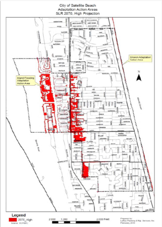
Image caption: Inland Flooding and Erosion AAAs for Satellite Beach with projected sea-level rise in 2070 (in red), using the high emissions scenario. IFAAA highlighted in red, and EAAA to the East of A1A.
Community Engagement & Enhanced Regulatory Boundaries
In Satellite Beach, public outreach is required to allow comments on data collection, methodologies, guiding factors to consider, and critical assets for the community. This included consideration of the sea-level scenario that should be assessed in city-level plans. Town hall meetings and a sea-level rise planning committee helped determine the sea-level curve used in this ordinance.
Ordinance No. 1159 includes a map of Satellite Beach with the U.S Army Corps of Engineers (USACE) high projections for the 2070 planning horizon to identify the Inland Flooding Adaptation Action Area (IFAAA), which helps Satellite Beach identify priority infrastructure and flood mitigation projects. This change requires that any infrastructure with a service life over 50 years that will be built by 2025 must plan for flooding out to the year 2070 in order to reduce infrastructure vulnerabilities. The map above illustrates this change, with the red areas representing USACE high inundation projections for 2070. It also includes the EAAAs, alongside the Inland Flooding Adaptation Action Areas (IFAAAs), which are areas “located within the Coastal High Hazard Area or FEMA 100 Year Flood Zone” or “areas which are expected to be inundated with water using the U.S. Army Corps of Engineers (USACE) high projections” for sea-level rise at the year 2070.
Publication Date: July 18, 2018
Related Organizations:
- City of Satellite Beach, Florida
Related Resources:
Sectors:
Resource Category:
Resource Types:
- Laws
States Affected:
Impacts:
- Flooding
- Coastal Flooding
- Extreme storms and hurricanes
- Sea-level rise
